Coordinates
Coordinates
 Shows GPS Coordinates on click
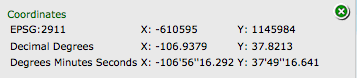
This tool returns the GPS coordinates of any point on the map.
CLICK the XY Tool and then CLICK the Map.
A window will pop up that shows the GPS coordinates at that point.
The coordinates are shown in several different formats:
1. The base map projection
2. Lat/Long WGS84 - This is a standard lat/long projection used as the default in most GPS units.
3. Degrees Minutes and Seconds